
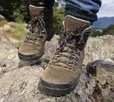
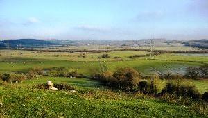
Discover hidden parts of the Vale as well as the popular and well trodden routes to The Clump, St Hilary and Stalling Downs & Cowbridge
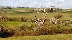
Explore villages and hamlets using quiet paths and tracks that will provide you with stunning views, quaint houses, beautiful hamlets and peaceful streams and lakes
All the walks be downloaded on your laptop/PC or smartphone
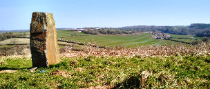
Gentle strolls and short walks: The Clump, St Hilary Down and The Garn / routes between St Hilary and Cowbridge / Points of Interest / North – Stalling Down
Moderate walks: West: 6.4 miles Aberthin Cowbridge Llanblethian / South West: 7.7 miles Llanblethian Siginstone Llandough / North East: 8.6 miles Llantrithyd Hensol
Monster walks: South East 9.1 miles Llantrithyd Llancarfan Treguff / North West 10.8 miles Llansannor Penllyn Cowbridge / South – 11.1 miles Llandough St Mary Church Flemingstone
Note: the articles below are shown in a random order, so will appear in a different place everytime you access this page
Free guided walks
Vale Secret Walks are for walkers of all abilities and for people who love the countryside, whether you are a sole traveller, a couple or a group. We offer a personal approach – each walk can be tailored to your requirements which could be:
- Low level rural stroll
- A walking tour of village pubs
- High level mountain challenge
- Coastal cliff walk
- 1 hour to all day
- Any day of the week
Walks are free - small donations to village funds appreciated.
We take into consideration the ability, experience and preferences of each walker.
- St Hilary – St Hilary Down – Aberthin – Stalling Down – St Hilary
- 3.8 miles-6.1 km / 2/3 hours / 390 feet ascent
- No stiles or farmyards
- Wide paths, tracks and roads
Click here to print/download more details, directions and maps of the route
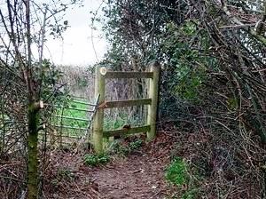
This is a broken step on a stile between the Downs and Stonacre on the footpath to Cowbridge
If you come across any broken stiles/gates or obstructions on a right of way in the Vale you can report it to the Council’s Public Rights of Way via Contact OneVale on 01446 700111 or
The more people that report it, the more chance of it being fixed
If you want an OS grid reference and/or a What 3 Words address please email
A circular walk from St Hilary to Llantrithyd and then Llancarfan where there is a homely village pub
A surprisingly demanding long walk using paths that are good but not well known
- St Hilary – The Garn – Llantrithyd – Llancarfan – Coed Arthur – Tre-Aubrey – St Hilary
- 8 miles / 3/4 hours / 830 feet ascent
- Lots of stiles and gates
- Mainly field paths and tracks, some country lanes
Click here to print/download more details, directions and maps of the route
This is the longest walk in the series with over 1,000 feet of ascent. There are three distinct sections: tracks and woodland to Llanblethian, then fields and little used paths and roads across Flemingston Moor to Llanbethery and finally a quiet country lane back to the village.
- St Hilary – Llanblethian – Llandough – St Mary Church – Flemingston – Llanbethery – St Hilary
- 11 miles-18km / 4½-5 ½ hours / 330m ascent
- Lots of stiles and gates
- Mainly field paths and tracks, some country lanes towards the end
Click here to print/download more details, directions and maps of the route

These are the most popular walks in the village - no stiles, gates or farmyards.
No need for a map, just follow these simple directions (the walks can be combined):
The Clump (30 minutes there and back)
- At the crossroads at the end of Church Crescent, turn left taking the lane/track straight up to The Clump
The Garn (1.8 miles / 30 to 45 minutes / flat)
- Take the lane by the post box and red telephone box towards Llantrithyd - ask a villager where they are
- At The Garn Farm (¾ mile), turn left
- Follow the zig zag lane which comes out on the main lane into the village at East Downs Farm (a further ¾ mile)
- Turn left back into the village – take great care because of vehicles
Despite saying no map is needed, click here to print/download more details, directions and maps of the routes
- Cowbridge Physic garden: The hidden treasure of the Vale
- Dyffryn House and Dyffryn Gardens
- Tinkinswood Burial Chamber
- St Lythans Chambered Tomb
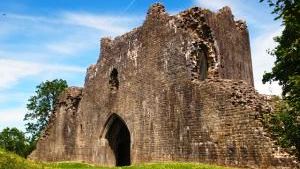
- St Quentin's Castle
- Natural Burial Ground
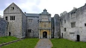
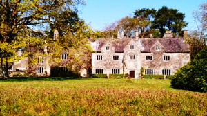
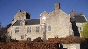
Beaupre Castle is a partly fortified 14th century manor house.
We cannot recommend walking the first part of the route as it is down a busy narrow country lane. From the Bush take the road out of the village, turn right immediately after the church (very narrow). At the junction in about 75 yards, go straight down the hill towards St Mary Church. After about a mile, turn left onto the St Athan Road and park in the lay-by which is immediately on the left.
From the lay-by, go over the stile and follow the clear path though the fields – a great spot for a picnic.
Click here to read about the history of the Castle.
- St Fagans (Welsh Folk Museum) - 2019 Museum of the Year
- St Donats Castle and Arts Centre
- Cosmeston Medieval Village
- Welsh Hawking Centre
- Llantrisant
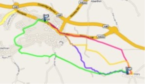
4 routes from St Hilary to Cowbridge - can be combined for circular walks
- A St Hilary Down – Roman Road: Good track, Roman road then road to Cowbridge 1.8 miles 40 min
- B St Hilary Down – Stoneacre: Good track, open land, fields then clear path to Cowbridge 1.9 miles 40 mins
- C New Beaupre – Stoneacre: Lane, fields then clear path to Cowbridge 1.9 miles 40 mins
- D New Beaupre – Llanblethian: Lane, track, fields, lanes, good path to Cowbridge 2.9 miles 1 hour 15 mins
Click here to print/download more details, directions and maps of the routes
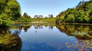
A moderate longish walk with good views, little used paths, a 360 vista, a hidden lake and woodland walks - there’s no pub along the route, so the Bush is the place to aim for!
- St Hilary – The Garn – Llantithyd House – Tair Onen – Hensol Woods – Hensol Lake – Welsh St Donats – Stalling Down – St Hilary Down – St Hilary
- 8 miles-13km / 3-4 hours / 650 feet-200m ascent
- A few stiles and gates
- About half on good paths and tracks – the rest on quiet country lanes
Click here to print/download more details, directions and maps of the route
Compared to the other walks, this is a strenuous walk but it provides lots of lovely views as it tracks the rim of the land around Penllyn Moors. About 1,000 feet of ascent. In return, you will see a secret filming location of Doctor Who, find a hidden well and walk through castle grounds. There’s no risk of getting too tired, as there are 5 pub stops along the route!
- St Hilary – The Downs – Aberthin – Llansannor – Penllyn – Cowbridge – St Hilary
- 10 miles / 4-5 hours / 1,000 feet ascent
- Lots of stiles and gates
- Mainly field paths and tracks, minimal road walking
Click here to print/download more details, directions and maps of the route
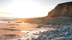
The Glamorgan Heritage Coast is a wonderful, world-class 14 mile / 23 km stretch of coastline from Ogmore to Aberthaw.
It includes a fantastic beach and bay at Southerndown at the western end, where there is also the Duraven Park and walled garden. There is a lighthouse at Nash Point and the historic St Donats Castle.
There are short and long walks along the coastal path. Look up the 303 bus - it will enable you to do a linear walk without retracing your steps!
When the tide is out it is possible to walk from Dunraven to Llantwit along the rocky and sandy shoreline.
Read more on the Vale of Glamorgan and Wikipedia websites.
Quiet valley track, meadowland, the byways of Llanblethian, a hidden ridge, the Victoria Inn in Signinstone, the splendour of Plas Llanmihangel and Church, the lanes of Llandough, Herbs in Wales then a peaceful vale walk back to the Bush Inn
- St Hilary – Llanblethian – Sigingston – Llanmihangel – Llandough – St Hilary
- 8 miles-13km / 3-4 hours / 720 feet-220m ascent
- All well marked lanes, tracks and paths; gentle uphill at finish
- Minor boggy factor if very wet, minimal road walking
Click here to print/download more details, directions and maps of the route
Coed Hills Community and Wedding Venue is about one mile east of the centre of the village
From the centre of the village, take the road past the post box and phone box. After about 3/4 mile, ignore the turn to Coed Hills Farm on the right; the entrance to the Arts Space is about 100 yards further along on the right.
Caves, mines and bats and plans – an update from Ewart and Nancy

Overview
Coed y Tor woodland, is the stretch of woodland on the left hand of the road as you walk out of the village downhill towards New Beaupre. It’s in the shape of a bent arm with the elbow being the rocky outcrop that overlooks New Beaupre. This is the Tor. The wood is classed as a PAWS - Plantation on Ancient Woodland Site. Originally, it was an ancient woodland and there are remains of large oak stumps dotted around, but those trees were removed and, possibly later, a larch crop was planted with ash naturally self-seeding. The ground flora indicates that the woodland floor is over 200 years old – the larch is about 50 years old.
![]()
Valeways is a unique voluntary environmental organisation which supports a diverse range of volunteers to re-open and promote the Vale of Glamorgan's glorious countryside. Activities include:
- a led walking walking programme around the Vale
- weekly cut and clear session to keep footpaths open, including the Millennium Heritage Trail
- easy walking/strolling
For more information visit their website or email
Terry Dennis volunteers with Valeways - email him if you have any queries or would like to know more:
Great views over the Vale, followed by peaceful meadow lands, unseen parts of Cowbridge and Llanblethian then a peek at St Quentin’s Castle – finishing with a gorgeous walk through the Vale back to the Bush Inn – and a well earned pint
- St Hilary – St Hilary Down – Stalling Down – Aberthin – Cowbridge – Llanblethian – New Beaupre – St Hilary
- 7 miles-11km / 2.5-3.5 hours / 500 feet-150m ascent
- A few stiles and gates
- Good paths and tracks, minimal road walking
Click here to print/download more details, directions and maps of the route
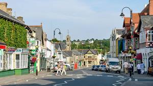
A circular walk to Cowbridge from St Hilary using lesser known tracks and paths. First down to New Beaupre woods, then across fields to the pretty village of Llanblethian. You can visit St Quentin’s Castle and the Physic Garden and a have a pit stop in Cowbridge before returning to St Hilary by St Hilary Down (and avoiding the main road!)
- 4.7 miles / 7.6 km
- 2 hours
- 2 pub stops
- Good paths, tracks and roads
Click here to print/download more details, directions and maps of the route